One of the questions I’m asked most frequently by my students is “which gps app is the most accurate” and “why does GaiaGPS overestimate distance when tracking?”.
Washington Trails Associateion (WTA) published an article “How Far Is It? The Truth Behind Trail Measurements” that delves into some of the reasons why GPS trackers tend to overestimate. In that article, Anna Johnson, co-founder of GaiaGPS, mentions that Gaia has algorithms to help filter out much of that error.
Not wanting to pick on Gaia, I wondered how other GPS tracking apps compared and decided to run an experiment, recording my track on three popular GPS apps–GaiaGPS, CalTopo and AllTrails–and comparing the results to theoretical values obtained using a planned route that I created in Gaia and CalTopo. While I wanted to see how the apps, running on my ancient iPhone SE (1st edition!) would compare to one another, I also wanted to see how they would measure up against my Garmin Instinct GPS watch.
The route I chose is one of my favorite conditioning hikes, a route on Tiger Mountain I affectionately call the “Section Tiger Conditioner” because it goes up the Section Line Trail to West Tiger 3, then over to Tiger 2 and Tiger 1 before heading down the Tiger Mountain Trail. This is a route for which I have a lot of data.
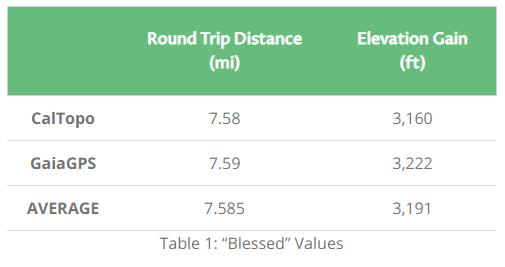
Plotting a route in both GaiaGPS and CalTopo yielded some consistent base values. As shown in Table 1, I would expect to hike about 7.58 miles with 3,190 feet of elevation gain.
At the trailhead, I began recording on my Garmin watch as well as all three apps. Once they were recording, I put the phone into airplane mode to conserve battery. I was a little curious how three apps requesting location data simultaneous would affect battery life, especially since I was also listening to music! After a quick initial bite (which I suspect was due to the apps downloading the nearby map data), the battery percentage stopped dropping and stayed remarkably consistent until and unless I went out of airplane mode.
When I reached the high point of the route at West Tiger 1’s Hiker’s Hut, I checked in to see how each app was faring.
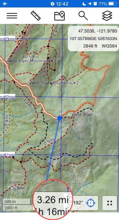
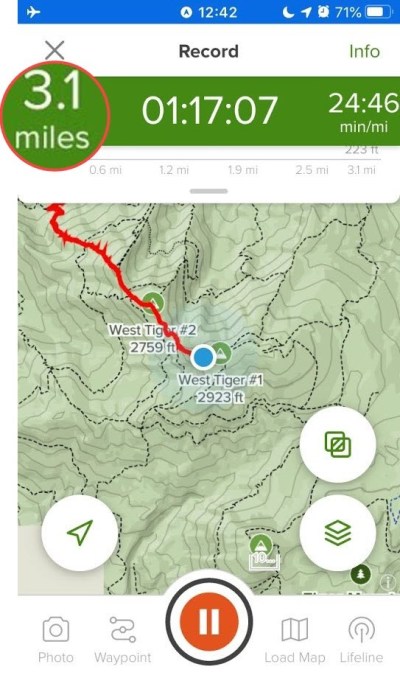
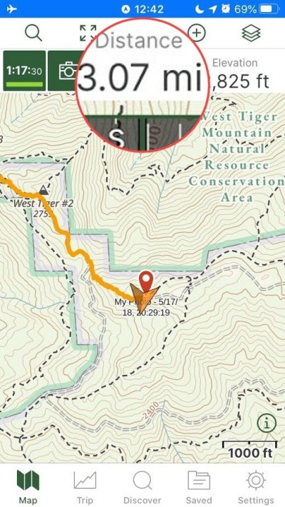
Based on the pre-planned route, the distance from the parking lot to the Hiker’s Hut should be only 2.94 miles, so at this check-in point all apps were overestimating distance, with Gaia being the closest and CalTopo the furthest. The battery had dropped only an insignificant couple of percentage points from when I initially entered airplane mode. I attribute this to the fact that the internal iOS location provider is orchestrated in such a way that having multiple apps requesting GPS data doesn’t add much more work than having a single app requesting it.
After admiring the few of Mount Rainier for a few minutes and downing some water, I began the hike/run down the Tiger Mountain Trail to the parking lot. This section of the trail is always so much muddier than the ascent, but it has a lot of cool little features and is not as heavily trafficked. After an hour or so, I returned to the parking lot and recorded the final statistics shown in Table 2.
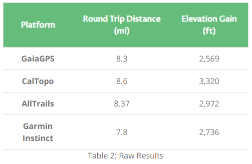
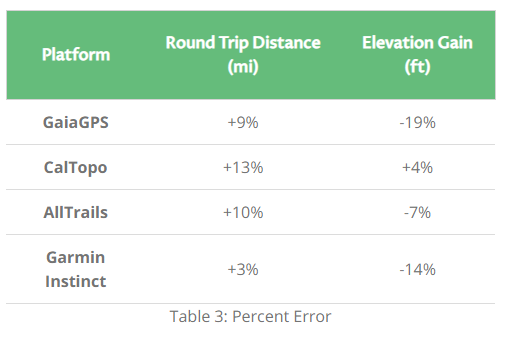
Then I compared these values to those expected from the route plan. In Table 3 positive numbers represent a recorded value higher than expected and negative numbers represent recorded values lower than expected.
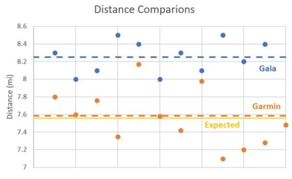
After taking these data points, I realized I had many, many recorded tracks of this route in my GaiaGPS and Garmin accounts and decided to add this data into my analysis to see how multiple recordings averaged out. It turns out my history has about three minor variations on this particular conditioning route, so I only considered those that matched the variation I did this day.
All platforms overestimated the distance, which is not unsurprising given the cumulative effects of GPS error. The Garmin Instinct was the closest, which makes sense considering it is a dedicated device that costs several times the cost of any of the GPS apps. However, while the average value matched the expected distance very closely, there was a lot of variability and spread in the recorded values.
While Gaia takes a lot of flak from my students, its smoothing algorithms produced values closer to truth than either AllTrails or CalTopo (which is the newest and has the most room for improvement). While Gaia was consistently high by about 9%, it showed less variability between recordings.
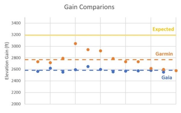
The biggest surprise for me was the massive inaccuracy in computed gain values. Using the profile view of the route, I did a quick back-of-the-envelope calculation and got an expected gain of 2,934 ft, about 92% of the more detailed calculation done by the route planning tools. After all, they account for even little hill and valley, no matter how small, and I just didn’t have the time for that!
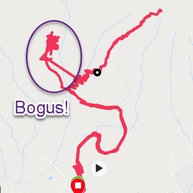
With the exception of CalTopo, all devices underestimated the amout of gain, quite significantly in the case of the Garmin and Gaia. The watch showed the same higher level of variability, which likely is a result of its smaller antenna. It also loves to occasionally (maybe 1 in 20 trips?) glitch hard, as shown in Figure 6. By contrast, I rarely experience such anomalies with Gaia, but I have seen tracks from others who have.
elevation error graph
Fig 5: Elevation Gain Scatterplot for Gaia and Garmin
Gaia was the most off, but shows remarkable consistency over several recordings. Were it not for the fact that I had manually calculated the expected gain myself, I would be tempted to assume that Gaia was right. Now my pet theory is that the same smoothing that helps mitigate the distance error due to GPS inaccuracy has a damping effect that suppresses the recorded gain.
CalTopo, while very off when it came to distance, was the only device that didn’t underestimate and was the closest overall. While I don’t have any technical insight into the inner workings of the app, I wonder if it is pulling elevation values from the map via lookup rather than taking the value from GPS.
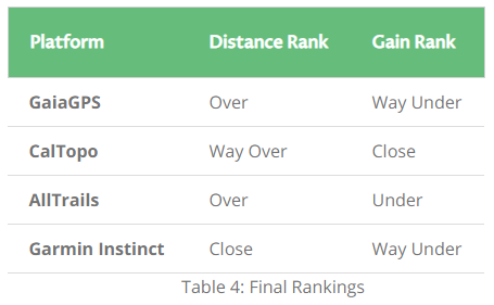
Summarizing the performance below, AllTrails makes a compelling case by not being too high over when tracking distance nor too low when tracking gain. Personally, I always like feeling good about myself, so overestimating is fine by me. I guess that means I should go with CalTopo for my outdoor adventures!

2 Responses
You refer to the more accurate ‘route planning tools’, but don’t explain what they are or their methodology. How do you know that those tools are any more accurate than on the ground measurements?
Very good comparison!! Thanks